Ahar
Pynes
This traditional floodwater harvesting system is indigenous
to south Bihar.
In south Bihar, the terrain has a marked slope -- 1 m per km
-- from south to north. The soil here is sandy and does not
retain water. Groundwater levels are low. Rivers in this region
swell only during the monsoon, but the water is swiftly carried
away or percolates down into the sand. All these factors make
floodwater harvesting the best option here, to which this system
is admirably suited.
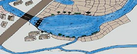
An ahar is a catchment basin embanked on three sides,
the 'fourth' side being the natural gradient of the land itself.
Ahar beds were also used to grow a rabi (winter) crop
after draining out the excess water that remained after kharif
(summer) cultivation.
Pynes are articifial channels constructed to utilise
river water in agricultural fields. Starting out from the river,
pynes meander through fields to end up in an ahar. Most
pynes flow within 10 km of a river and their length is
not more than 20 km.
The ahar-pyne system received a death-blow under the nineteenth-century
British colonial regime. The post-independent state was hardly
better. In 1949, a Flood Advisory Committee investigating continuous
floods in Bihar's Gaya district came to the conclusion that
"the fundamental reason for recurrence of floods was the
destruction of the old irrigational system in the district."
Of late, though, some villages in Bihar have taken up the initiative
to re-build and re-use the system. One such village is Dihra.
It is a small village 28 km southwest of Patna city. In 1995,
some village youths realised that they could impound the waters
of the Pachuhuan (a seasonal stream passing through the village
that falls into the nearby river Punpun) and use its bed as
a reservoir to meet the village's irrigation needs. Essentially,
this meant creating an ahar-pyne system
After many doubts, the village powers-that-be gave the go-ahead.
Money was collected and work began in May 1995. After a month
of shramdaan (voluntary labour) the villagers completed their
work mid-June.
Their efforts have borne fruit. By 2000 AD, the ahar was irrigating
80 ha of land. The people grow two cereal crops and one crop
of vegetables every year. The returns from the sale of what
they produce are good. The village is no longer a poor one.
|
|
|
Bengal's
Inundation Channel
Bengal once had an extraordinary
system of inundation canals. Sir William Willcocks, a British
irrigation expert who had also worked in Egypt and Iraq, claimed
that inundation canals were in vogue in the region till about
two centuries ago. Floodwater entered the fields through the
inundation canals, carrying not only rich silt but also fish,
which swam through these canals into the lakes and tanks to
feed on the larva of mosquitoes. This helped to check malaria
in this region. According to Willcocks, the ancient system of
overflow irrigation had lasted for thousands of years. Unfortunately,
during the Afghan-Maratha war in the 18th century and the subsequent
British conquest of India, this irrigation system was neglected,
and was never revived.
According to Willcocks, the distinguishing features of the irrigation
system were:
1.) the canals were broad and shallow, carrying the crest waters
of the river floods, rich in fine clay and free from coarse
sand;
2.) the canals were long and continuous and fairly parallel
to each other, and at the right distance from each other for
purposes of irrigation;
3.) irrigation was performed by cuts in the banks of the canals,
which were closed when the flood was over. |
|
|
Dighis
Emperor Shahjahan (1627-58 AD) first shifted the city from the
Aravalli hills towards the plains of the Yamuna. But he made
sufficient arrangements to meet the water needs of the new palace,
the army, and the common people. His system of Shahjahani canals
and dighis was probably the
best creation of the time.
Shahjahan ordered Ali Mardan Khan and his Persian artisans to
bring the waters of the Yamuna to the city and to his palace.
Ali Mardan Khan not only brought Yamuna waters to the palace,
but also linked this canal with another from Sirmaur hills,
presently located on the Delhi border near Najafgarh. The new
canal, Ali Mardan canal, channelled the waters of the Sahibi
river basin to merge into the old canal.
In the main city, the canal charged dighis and wells. A dighi
was a square or circular reservoir of about 0.38 m by 0.38 m
with steps to enter. Each dighi had its own sluice gates. People
were not allowed to bathe or wash clothes on the steps of the
dighi. However, one was free to take water for personal use.
People generally hired a kahar or a mashki to draw water from
the dighis. Most of the houses had either their own wells or
had smaller dighis on their premises. In the event of canal
waters not reaching the town and the dighis consequently running
dry, wells were the main source of water. Some of the major
wells were Indara kuan near the present Jubilee cinema, Pahar-wala-kuan
near Gali-pahar-wali, and Chah Rahat near Chhipiwara (feeding
water to the Jama Masjid).
In 1843, Shahjahanabad had 607 wells, of which 52 provided sweetwater.
Today 80 per cent of the wells are closed because the water
is contaminated by the sewer system.
Baolis
Besides tanks, sultans and their nobles built and maintained
many baolis (stepwells). These baolis were secular structures
from which everyone could draw water. Gandak-ki-baoli (so named
because its water has gandak or sulphur) was built during the
reign of Sultan Iltutmish. The water of this beautiful rock-hewn
baoli is still used for washing and bathing. Adjacent to this,
there are the ruins of other baolis like Rajon-ki-baoli, a baoli
in the Dargah of Kaki Saheb, and a caved baoli behind Mahavir
Sthal. During this period baolis were built in other parts of
the city too.
Muhammad-bin-Tughlaq (1325-51 AD) inherited Delhi with three
competing habitations, and added a fourth one to it - Jahanpanah
- which means the shelter of the world. The Satpula (meaning
seven spans) was built to regulate water supply for irrigating
the area falling outside the city. Built across the southern
wall of Jahanpanah, it is a dam towering 64.96 m above ground
level. Its seven principal spans were sluices that controlled
the water in an artificial lake.)
|