|
The
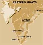
Eastern Ghats, a rugged, hilly terrain
running almost parallel to the eastern coast of India, constitutes
the watershed of many big rivers. The Eastern Ghats broadly
cover three regions: southern Orissa highlands; Chittoor and
Cuddapah districts of the Rayalaseema region in Andhra Pradesh;
and the uplands and Nilgiri region of Tamil Nadu.
The southern Orissa highlands comprise the Dandakaranya region
of Orissa, which includes the districts of Bolangir, Ganjam,
Phulbani, Kalahandi, Koraput and part of Puri. The average
rainfall in this region is between 2,000-3,000 mm. The hill
ranges of Cuddapah district in the Rayalaseema region form
the central portion of the Eastern Ghats, and the district
is drained mainly by the Pennar river and its tributaries.
The average annual rainfall here is 685 mm. Chittoor district
is characterised by hills, plains and uplands. The Eastern
Ghats in Tamil Nadu cover Dharmapuri, North Arcot, Salem and
Nilgiri districts. The uplands and the Nilgiri region of Tamil
Nadu have wide valleys made by the Cauvery and its tributaries.
In general, the elevation here is over 900 metres (m) in the
west due to the Nilgiri hills. The western and eastern flanks
get an annual rainfall of 800-2,000 mm but the central part
of the uplands is almost dry.
Find more about
Techniques prevalent in this region
- Traditional
People
who harvest rain
|