The ground water
availability in the territory is controlled by the hydrogeological
situation characterized by occurrence of alluvial formation and quartzitic
hard rocks. The hydrologeological set up and the groundwater occurrence
is further influenced by the following distinct physiographic unit:
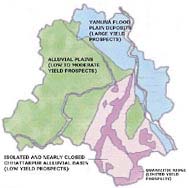
The
Delhi ridge which is the northernmost extension of Aravalli mountain
consists of quartzite rocks and extends from southern parts of the
territory to western bank of Yamuna for about 35 kilometers. The alluvial
formations overlying the quartizitic bedrock have different nature
on either side of the ridge. The Yamuna flood plain contain a distinct
river deposit. The nearly closed Chattarpur alluvial basin covering
an areas of about 48 Km ² is occupied by alluvium derived from the
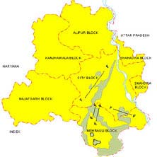
adjacent quartzite ridge. The map showing geological units is given
in the picture.
- Alluvial plain on eastern and western
sides of the ridge
- Yamuna flood plain deposits
- Isolated and nearly closed Chattarpur
alluvial basin
- NNE-SSW trending Quartzitic Ridge.
CLICK TO ENLARGE

|

|
Potential Areas and Availability of Unsaturated Zone for Recharge:
Any man-made scheme or facility that adds water to an aquifer
system may be considered to be an artificial recharge to ground
water. It may be planned as in the case of a pit that has been
dug for the purpose of putting water into an aquifer, or it may
be unplanned or incidental to human activity in the case of surface
water irrigation. The pre-requisites for undertaking artificial
recharge to ground water are:
1. Favourable hydrological set-up.
2. Developed aquifers.
3. Availability of unpolluted surface water.
4. Ground water dependent community.
Based on the above criteria, artificial recharge to ground water
in South and South west district needs to be given top priority
so as to make the ground water resources sustainable and improve
the quality which is deteriorating because of over-exploitation.
Thickness of unsaturated zone in Tughlaqabad, Okhla, Khanpur,
Pushp Vihar, Sainik Farm, Saket, Mehrauli and surrounding areas
of Gadaipur, Jaunapur and Ghitorni villages of South district
varies from 45 to 50 m. In areas like Greater Kailash- I &
II, Chittaranjanpark, Green Park, Lado Sarai and surrounding areas
the thickness of unsaturated zone is about 25 m. Vasant kunj,
Vasant Vihar, Samalkha and Rajokri areas of South west districts
have unsaturated zone thickness ranging from 35 to 45 m. The Central
part of South west districts have unsaturated zone of 12 to 15
m. Thus, very potential unsaturated aquifer system is available
in these two districts shows that, more and more areas are becoming
brackish to saline because of exhaustion of fresh ground water
present at shallow depths and upcoming of brackish water into
fresh water aquifers.
Soil Classification & Distribution
The soils of the Delhi area are mostly light with subordinate
amount of medium texture soils. The light texture soils are represented
by sandy, loamy, sand and sany loam; whereas medium texture soils
are represented by loam silty loam. Textural classes of soils
as revealed from the grain size analyses of 313 soil samples,
carried out by Messere Radio Foundation Limited and Hazard &
Co., Bombay for the Metropolitan Project of Delhi area(Railway),
are shown in Plate - III. The soils that occur in all the blocks
are generally suitable for irrigating moderately salt resistant
crops such as wheat, barley and mustard.
|


